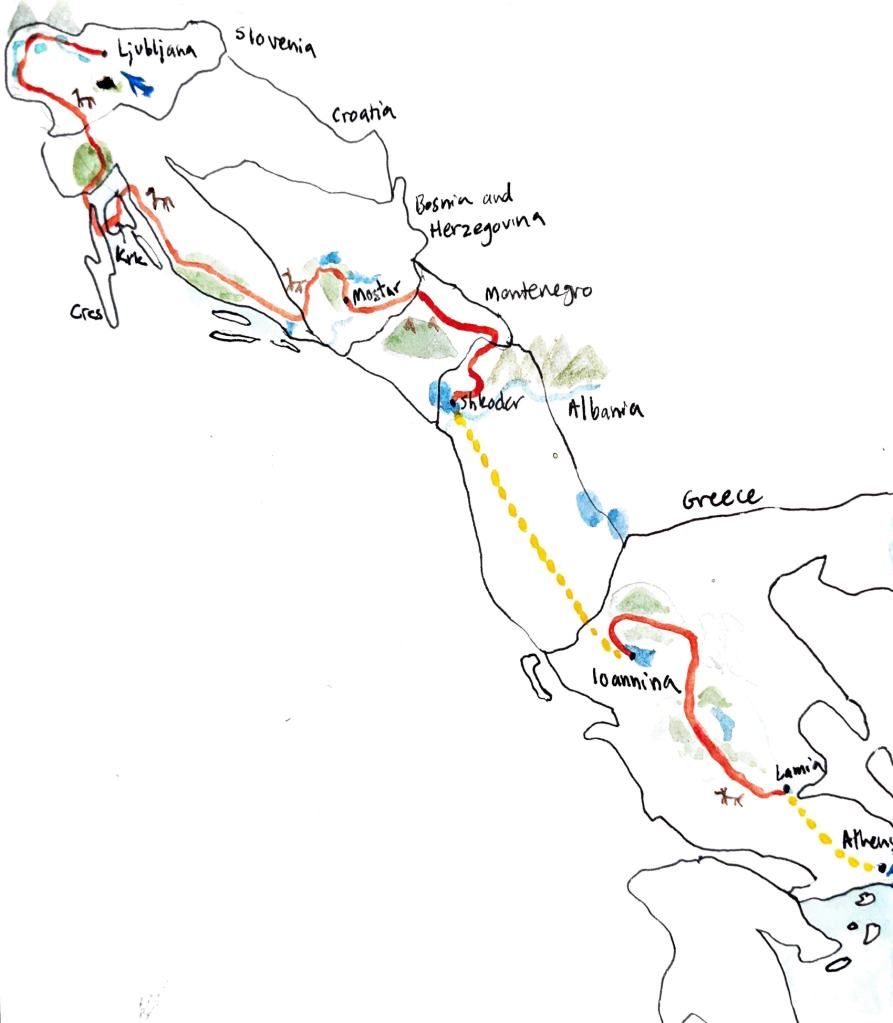
Europe Route Recommendations
This is the route that we would recommend; what we would do if we did it again.
In some cases, that means I’ve recommended sections that we never biked on, but that seem better than what we did based on my research. We didn’t have the time to return to test out these alternatives, so no guarantees. I’ll flag those sections in the descriptions.
Note that this is a draft, written on my phone while traveling. Expect typos, poor formatting, and missing information. Around February 2026, I’ll return to polish this up.
I (Evelyn) relied heavily on Trans Dinarica and Bikepacking.com for route planning. Neither of them were exactly what we were looking for- Trans Dinarica was too much asphalt (their philosophy: most safe from traffic while most pavement possible so it is rideable for the largest array of bikes and abilities) and the Bikepacking.com routes were meant for mountain bikes (their philosophy: seek out the most interesting terrain possible, from stairs to rocky MTB trails to bushwhacking). We patched together a route that fit our sweet spot of rigid gravel bikes looking for some adventure.
Route planning manifesto:
- We were riding rigid gravel bikes with 44mm-2.1 knobby tires and gear for a 4 month journey (a handlebar bag, frame bag, seatpost bag/rack, and backpack each). Each of our bikes weighed about 45-50lbs total when fully packed, including water.
- We prefer to keep things interesting, with gravel one day and asphalt the next, a long day followed by a short day.
- We love the adventure of all kinds of gravel, but we generally want to bike not hike. We found hike a bike adventures are fun in the morning but a slog at the end of a ride. Sometimes I’ve left in short hike a bikes that were particularly scenic or worth it. Whether something is bike able will depend on skill level and gearing- there are many gravel sections Meg could ride that I walked.
- Safety. Our reference routes largely did an excellent job of avoiding car traffic. The exception is some of the Trans Dinarica connector routes and secondary routes that are mostly road. For example, we found the coastal road in Croatia too unsafe to bike, as well as the Podgorica-Shkoder connection. We also heard multiple bad reviews of Eurovelo 8. Aside from traffic risk, there were three main route risks in the region that we routed to avoid: high winds (Bora winds of Croatia/Bosnia), grizzly bears (e.g. Velebit, Durmitor), and shepard dogs (wherever there are sheep and bears, so the mountains of Bosnia, Montenegro, Albania, and Greece). We want to have fun and explore, not needlessly suffer or take unnecessary risks.
- Comfort/resupply. These routes include the specific places we chose to camp and resupply, or at least the town we resupplied. We went to a grocery store every 1-2 days to resupply so we didn’t have to carry extra food. Typically routes don’t include detours for housing or food and leave it up to each individual to decide. The routes below are broken out into stages and include the places we stayed (except Airbnbs in cities). If you share our pacing and preference for cheap and decent campsites (and cabins in cold weather), you can follow this exactly. In Feb 2026, I’ll post a version of the route without these deviations so you can DYI from there if you prefer.
- Simple routes are better. Where possible, we like to get in the zone instead of stopping to check directions and often taking wrong turns. (e.g. Komoot often included and Bikepacking.com sometimes includes detours for very short sections of gravel.)
I’ve tried to give credit to all of our reference routes in the descriptions below. I’ve included all of our GPX files that are based off of publicly available/free routes (e.g. Bikepacking.com or Komoot). I have not included the Trans Dinarica routes because they ask for payment for their route development. I include any notes we had on those sections below, but refer you to the Trans Dinarica website for their route.
General recommendations across countries:
- Reach out to housing options at least a day ahead of time over email or Whatsapp to confirm availability. Some housing is run by one person and they might be out of town for the day but willing to arrange something, or closed early at the end of the season. Hosts can reserve a space for you if you see going to show up later after a long day of biking. (In high season, you’ll probably need to book farther in advance.)
- Buses: we took our bikes on buses in Croatia, Montenegro, Albania, and Greece. The process was the same for all: show up at the bus station, tell the ticket person where you want to go, they tell you the time options, you say which you want and ask if bikes can go. They look annoyed and say let me call the driver and ask. They say the driver says ok but you will need to pay them extra, directly. Show up at the station an hour before if you don’t have your tickets or at least a half hour before, so you can talk to the driver as soon as your bus pulls in. The driver will complain to justify asking for a bribe, but it’s really no issue. The driver may also try to load your bike in for you or tell you where to put it- we found the best policy here was to stack our bikes how we liked and confirm that they were ok with it after. The bribe is typically 10 euros per bike. One driver asked for 15 per bike, one driver in Albania let us do it for free. One bus in Greece refused (see Greece details below), but another issued us bike- specific tickets so we paid the bus company instead of the driver directly. The Croatia bus had excellent free wifi. No buses had bathrooms. Buses ranged in cost from 20-30 euros a person for a 3-6 hour ride, plus the 10 euros per bike fee.
- Trains: we took the train in Montenegro. There are also trains in Croatia, Bosnia, and Greece. The Croatia train intercepts the route at Rjieka, the Bosnia train at Mostar (find Eurail maps online). In Montenegro you buy your ticket on the train and bikes were allowed only at the back of the train, which could only fit two bikes.
- Ferry: we took ferries in Croatia, Albania, and Greece. In Croatia you buy your ticket at the ferry port. All the ferries we experienced were car ferries, so bikes were no problem. In Albania and Greece, you bought your ticket online. You could buy directly from the seller or through middleman websites. The middleman websites can show you which companies are running ferries at which times, but the tickets are cheaper direct from the company. There are both car and passenger-only high speed ferries. We didn’t try to get our bikes on the high speed ones and doubt we would have had any luck (we took some passenger-only ferries in Greece and did not see an easy out of the way place to put a bike. The high speed ones are like airplane seating inside, safety video and all).
- Taxi: we took a taxi with our bikes in Croatia, and a taxi with bike boxes in Athens. There’s no special secret to the taxis- outside of cities you just look up taxi numbers and contact via WhatsApp, or ask around at a restaurant or hotel to see if they know anyone. In cities, there is usually a taxi app like Uber or Lyft. The XL option is not as XL as it is in the US- expect to fit one, maybe two, bike boxes and one person in the front seat.
Slovenia———
Slovenia airport to Airbnb:
There is a bike assembly station at the Ljubljana airport, right next to the oversize luggage in baggage claim. You can bike to the city center almost entirely on bike paths and lanes! The default Komoot “bike ride” route works pretty well, except it unnecessarily takes you down stairs and leads you into a construction zone as of September 2025. Here’s a corrected version:
My reference for the first four days of Slovenia was the Bikepacking.com West Loop route, Soca river variant. Changes:
- Based on comments online, the first day seemed quite fun but too intense for the start to our four-month trip, so I rerouted the first day to limit elevation and unnecessary hike-a-bike. It was still a lovely ride.
- We opted to camp at campsites and avoid risking the 400+ euro fine for wildcamping in Slovenia. We picked the cheapest campsites in each area with decent ratings (see @offderaills for full campsite reviews). Camping in Slovenia is a bit pricey (30-40 euros for two people and a tent) but you get what you pay for- the campsites are well supplied and maintained and very comfortable. Some days the campsites were perfectly on route, but sometimes they were a bit out of the way, as reflected in the routes below.
- I updated the routes after we rode them to avoid some short patches of gravel that we didn’t think were worth the extra turns, a short path that explicitly prohibits bikes now, etc.
These days were really excellent route-wise.
Other references I didn’t end up relying on: Lael Slovenia rally (the gondola looks cool!) and Trans Dinarica.
Ljubljana to Camp Trnovc:
Camp Trnovc to Kranska Gorja (Camp Spik):
Kranska Gorja to Bovec (Camp Polonovik):
Note: Camp Polonovik was not the best campsite (e.g. small, muddy plots), but it was cheap. There are plentiful, nearby alternatives that should have nicer facilities for a bit more.
Bovec to Nova Gorica (Camp Brda):
See our Instagram for reviews of these campsites.
The last two days of Slovenia we made up as we went along. There are many bike-friendly ways to cross the southern half of the country (see 2 from Trans Dinarica and the Bikepacking West Loop for reference). However, there were fewer campsites along the way that fit our budget and general route. The three sites that looked the best where: Hostel Kras in Pliskovica, Bradja Camping in Storje, and Camping the Sunrise Hill north of Illirska Bistrica. Only the latter had availability and was open past September 15, so we booked it across Slovenia in a mostly asphalt route. If one of the other camping options works for you, check out other route options for more gravel (and elevation).
Nova Gorica to Illirska Bistrica (Camping Sunrise Hill): Biking through wine country ended up being quite pleasant, though there were a few times we had to be on busier roads that didn’t feel as safe. The route below has been adapted to avoid those areas as much as possible.
Illirska Bistrica (IB), Slovenia to Icici, Croatia (Camp Opatija):
We initially planned to follow the Bikepacking.com Adriatic Crest route from Illirska Bistrica to Opatija, but ended up winging it with a Komoot gravel route in a bid for a shorter day. That plan backfired somewhat- much of the Komoot route was not rideable, especially on a rainy day (this area is much more damp and slippery than the rest of Slovenia). But Komoot also showed us some really great sections. The following route is edited heavily to preserve the good gravel we found and remove the hike a bikes. Note this skips an official border crossing into Croatia- we had no issues with this later on when leaving Croatia. Though the final route is enjoyable, if you have more time, I’d recommend exploring other ways to get to the Cres ferry. Opatija was the worst campsite we stayed at in the region, so if you can avoid it, I would, and Istra has some great gravel (e.g. Lael rally, Istra bikepacking race). Note if you want to purchase bear spray for the mountains later on, a hunting store in IB is the only place on the route we were able to find it (for 70 euros).
Croatia ———
Icici to Cres Town (Kovacine): We opted for asphalt on Cres instead of gravel to fit our timeline, and it was lovely. We arrived on a rainy day in low season so there was basically no traffic other than a short burst of cars when the ferry arrived. In high season I would recommend exploring the gravel options. We stayed at Camp Kovacine, which is an INCREDIBLE camping site/compound. Cannot recommend highly enough.
Route references: Adriatic Crest, Lael Croatia rally 2025.
Cres Town to Krk (Camp Slamni): Krk has many mountain bike trails with lots of big, loose rocks, so some of the Krk sections of this bikepacking route are the most technical. This route is edited from what we did to preserve the fun gravel and avoid unrideable MTB trails. This route also skips a very steep descent to the Cres ferry port in favor of the longer and slower descent on the main car road. In high season, you may prefer the steeper descent. Reference: Bikepacking.comAdriatic Crest.
Here’s where I suggest you depart from our route. We didn’t enjoy our time on mainland Croatia nearly as much as the islands. The traffic was worse, the campsites were worse, and the people were less welcoming and kind.
Option 1. Closest to our route. Bike to crikvenica, and then take the afternoon bus from Crikvenica to Prizna, and the ferry to Pag. This should be doable in one day. The only camping option near Crikvenica is Kamp Selce, which was very expensive for the low quality (if they try to tell you camping is 50$ ask for the “free zone” which is a patch of overgrown grass you can camp in for 38$), so I’d recommend skipping if possible. We didn’t take these buses so I can’t confirm if they take bikes. The two Croatia buses we took did accept bikes for a 10$/bike bribe to the driver.
Krk to Selce (Kamp Selce):
Option 2. Bike to Rjieka and take the bus to Prizna/Pag from there.
Option 3. Bus from Krk Town to Rijeka and take the bus to Prizna/Pag from there. The only way to get off Krk is a car bridge that is doable but scary (there is a pedestrian path option we did not use). This way you could avoid that and do a fun loop around Krk back to Krk Town. But it does mean two bus fares plus bike bribes.
Option 4. If comfortable with bear and wind risk: First day: bike from Krk to the highlands past Selce and wildcamp off of a gravel road (to avoid the overpriced and unfriendly Kamp Selce). I’ve put the pin where I remember there being an abandoned rest area, but no guarantees.
Then follow Trans Dinarica routes through Velebit (either connecting to Pag or just straight through).
Pag (Camp Strasko) to Rtina (Micoce): The Trans Dinarica route was great through Pag. The salt museum and cheese factory on Pag Town close early on Mondays, but if you are caught out you can get the same cheese at the grocery and there is another salt museum in Nin. Camp Strasko was Kovacine-level nice, at a lower price.
From here we deviated from our planned route to escape the Bora wind. If you have no wind to escape, I recommend the Trans Dinarica routes as reference. Stayed at Camp Dido for 15 euros for a tent for the night, which was great and has a lovely host named Sandra.
Rtina to Zadar (Camp Dido):
Mountains of Bosnia and Herzegovina and Montenegro —————
From Mostar to Zabljak, we took the Trans Dinarica and would highly recommend it. It was the most beautiful section overall. Note that there are no ATMs between Mostar and Zabljak, so make sure to carry enough marks/euros. Bosnians and Montenegrins close to the Bosnian border will accept euros and marks interchangeably. We recommend reaching out to housing options at least the day before over email or Whatsapp to confirm. Some housing is run by one person and they might be out of town for the day, or closed early at the end of the season. Here are miscellaneous route notes:
- Boracko Lake to Tusila. The pass to Tusila was open but sections were covered in enough snow that we walked our bikes. Stayed at the outdoor center, a lovely cozy mountain hut. 20 euros per person to stay in a bunk bed, 20 more euros for dinner and breakfast. You can opt to cook your own food on your own camp stove outside if you prefer.
- Mostar to Boracko Lake: There were 2 huge shepard dogs at top of the gravel ridge that were friendly when we got of our bikes and approached on foot. Boracko Lake is a major tourist spot and was very dead in early October, with no camping open, only 1 guesthouse open, and the mini-market open upon request at the cafe. It probably would be fine to camp at one of the closed campsites, but there were many wild dogs. Stayed at: Apartman NeSa Boračko jezero (40 euros for one apartment with two double beds and a kitchen area). Multiple bikepackers we met went to Konjic for the night instead- it may be a better option.
- Tusila to Kalinovik. There is a decently stocked minimart in this town at 43.5042840, 18.4452349. Stayed at a cabin at 43.4812541, 18.4782100. 30 euros for the cabin with hot water and a kitchen, heated by a wood stove. There was a sign for a cyclist-friendly camp at 43.4871941, 18.4893790.
- Kalinovik to Scepan Polje: The road parallel to canyon at the end of the day was okay in the low season but I think traffic may make it a bit anxious in the high season. There doesn’t seem to be a better way around. One of the rafting camps had a pack of dogs guarding it who chased us.
- Scepan Polje to Trsa: Stayed at Camping Zeleni Green Forest. Vida, the host, is lovely. 20 euros for a tent, 30 euros for a cabin (50 euros for 2 nights), 10 euros per person for dinner, 8 euros per person for breakfast. If it’s been cold and raining (and there is snow in the pass), Vida can help you check if the Durmitor pass is open.
- Trsa to Zabljak: Stayed at Autocamp Mlinski Potok for 15 euros for a tent. The hosts were friendly and generous and offered us tea, but the old man patted me on the ass. I’d go to Ivan Do next time. The walk to the Black Lake is nice and we were never asked to pay a fee.
Montenegro has an amazing system of Panoramic Highways. They are quiet one or two lane asphalt roads with amazing views. our favorite parts of the Trans Dinarica routes in Montenegro were on these roads. I recommend referring to the Panoramic Highways when route planning in Montenegro instead of the Trans Dinarica. The Trans Dinarica route will take you on gravel roads that are much more likely to have aggressive shepard dogs. There are mountain bike trails in Montenegro that might be safer from shepard dogs (Montenegro Mountain Madness and the Trans Balkan Race have routes you can buy) but we did not explore those.
The route from Zabljak to Kolasin was full of shepard dogs. You can’t count on the shepards to be present or control their dogs- one shepard just looked and us and shrugged as his massive dog hunted us down. I would not recommend this route. There aren’t great alternatives between Zabljak and Kolasin- the northern route following the Panoramic Highway is closed as of this writing, and the southern route is the main car route. Zabljak isn’t that fabulous, so I would just skip it next time and follow the Panoramic Highways to Niksic and either continue to Podgorica or train from Niksic to Podgorica. Bikes are accepted on the train but only in the final car. Be prepared to hustle to the final car and load your bikes on as quickly as possible to avoid delaying the train. You pay in cash on the train (we paid 10 euros total for two people and two bikes from Kolašin to Podgorica). The train has compartments like Harry Potter!
Podgorica and Southeastern Montenegro Loop ———
Podgorica is a nice place to resupply and take care of any medical needs. Specifically, we found that you can get a tetanus short or a rabies vaccine at their public health center for ~44 euros per shot [see the dogs, cats, and immunizations blog appendix for more details]
Around Podgorica, we found Purple Eye Estate to be the best and cheapest camping option. One tent is 10 euros. The family also offers dinner and wine tastings at additional cost. A glass of the house wine is 2.50. We cycled between Purple Eye and Podgorica multiple times, so we can recommend two different routes depending on the time of day. All of those routes end at a yummy Turkish bakery in Podgorica. On a Sunday afternoon or early on a weekday morning (before 8am), this route (https://www.komoot.com/tour/2672723136?ref=aso&share_token=aeGGaP1Gw5qqmKhuKGhBth1zI9nF8uNY4LcFTRuaz9Xc2g4xFX) with a short stint on the highway is fine. In medium traffic times, this route avoiding the highway part works (https://www.komoot.com/tour/2672722786?ref=aso&share_token=aoyINYD4W402gLpt41a36AaTHm72sg8MnANUKs2BwoOPDQPsgL). During rush hour or two avoid main roads, this back roads route is preferable (though longer and with more barking dogs) (https://www.komoot.com/tour/2672733242?ref=aso&share_token=afn29HXaz3HPssW5MfFWM4CbN21MSxcKaX0Bv7GPQSALJkoxz2).
From Podgorica we explored southeastern Montenegro with Lake Skadar and the coast. We had a week before we needed to be back in Podgorica for a second vaccine, so we took our time. This loop could be a fun independent trip- you could squish it into a few days or take your time and explore as we did. Again, this route relies heavily on the Panoramic Highways.
Purple Eye Estate to Virpazar/Camp Radoman: This is the first and last day of the loop. It is based on a popular out and back from Podgorica along the Lake Skadar. That route and the default on Komoot will take you out of town on a sketchy highway- we tried it on the way out of town and did not want to repeat. This route is longer but safer and more scenic. Another option would be to take the train from Podgorica to Virpazar, set up camp at Radoman and then do an out and back along the lake. Radoman is a lovely little camp by a small family vineyard that charges 15 euros for one tent. Washing machine costs 5 euros to use. They have one apartment available. Virpazar does have a grocery but it is down the hill from the campsite so you’d need to bike back up that hill at the end of the day. I’ve put a Voli (grocery chain) on the route out of Podgorica for stocking up earlier in the day. There is also a lovely cafe along Lake Skadar on the route.
Virpazar/Camp Radoman to a wildcamp along the lake: You can continue straight to Uljce to skip the wild camp (most cyclists do Virpazar to Skadar in one day). If you do camp here, LEAVE NO TRACE.
Alternatives:
- Stay at Sashi apartments by Lake Sas. It is supposed to be good bird watching, rooms should be around 30 euros for a double, and the accompanying restaurant is supposed to be good. You could resupply in Vladimir if needed. (See the next day for the route)
- You could go on to Skadar this day- if you do, make sure to go through the official border crossing. Komoot will show you a potential shortcut, but if you don’t have the proper stamps, we heard from other cyclists that you’ll run into issues leaving the country.
Wildcamp to Ulcinj: Ulcinj is an interesting little town- it’s so close to the border that it is like a little slice of Albania within Montenegro. There are flamingos at abandoned salt flats just out of town- it is very peaceful to bike out there and observe (2 euro per person fee, bring exact change). There are many campsites along the beach, east of town. We stayed at Safari Camping for 18 euros for one tent, which was fine but facilities were mediocre and there were lots of wild dogs. That campsite or a similar one nearby is best if you want to maximize beach time or minimize expenses. Otherwise, I might stay at Hostel Pirate or Olive Trees Glamping next time to be a bit closer to the Old Town. The route is just set to go to Ulcinj’s Old Town to reflect my ambivalence about the housing options. In terms of route, we took the highway from Vladimir to Ulcinj and it was fine but not ideal- we had a close call with a tour bus and a surprise short tunnel. The route I’m recommending below is Komoot’s gravel recommendation to avoid highway where possible- we didn’t try this ourselves, but the gravel quality looks decent from Google Maps satellite.
Ulcinj to Bar: Komoot’s gravel route will take you up by the windmills, which seems pretty cool. However, there were high winds the day that we did this route, so we opted for a more sheltered option. As of October 2025 there was construction on the road from Krute to Dobra Voda, but bikes and some cars can pass through (just think of it as bonus gravel :). We stayed in an Airbnb in Bar to avoid thunderstorms, but in nice weather I’d go to Bartula My Olive Garden camp. The no-windmills route does include the short tunnel but you are going downhill so it goes much faster.
Here’s the route that would go by the windmills: https://www.komoot.com/tour/2635528867?ref=aso&share_token=aZhEqkp4GjwW1gtxdyDVKVnF9v0cZkgwMLgjOi3neWTvHVjzJ5
Bar to Virpazar/Camp Radoman: This turned out to be a lovely route that reminded us of Bosnia. The gravel road out of town from Stari Bar was particularly nice. We found Stari Bar to be very touristy and crowded- just the view from the road was nice and then we moved on. Komoot thinks there is a long, narrow tunnel that you can use as a shortcut to avoid some elevation, but locals warned us against it, and there are wild horses near the entrance and sometimes inside the tunnel. The Virpazar grocery is conveniently at the end of the day before the hill up to the campsite. https://www.komoot.com/tour/2639052656?ref=aso&share_token=anifo44vCXLja5TdE6Rr4bm25Uoxepr0K5yWwHdH2aGkjRt6TK
Radoman to Podgorica: Reverse of the route above.
Albania ———
We decided to skip Albania. We heard from many other cyclists that the central and coastal routes down Albania were unsafe traffic-wise and not fun. The Trans Dinarica route along the eastern side is likely a safer route from cars, but the internet says shepard dogs are plentiful so we elected to avoid. I’m looking forward to returning to Albania on foot one day to hike the Accursed Mountains, see the art and architecture of Tirana, and chill in Sarande. We bused straight to Sarande and then took a ferry to Corfu from there.
If you want to bus across Albania, here are the details. No bus goes straight from Podgorica to Sarande, you need to transfer at Tirana. Go to the Podgorica Bus Station and ask at the information both for a ticket to Tirana. There are more frequent buses than what we saw posted online. Our ticket from Podgorica to Tirana was ~25 euros. You bribe the driver to put your bike on- he hemmed and hawed and asked for 15 euros each even though there was plenty of space. I think we could have brought him down to 10 but we didn’t try. The bus is supposed to be 4-5 hrs but it took 6 because our bus was broken. One rest stop. In Tirana there are 2 bus stations: the North South bus station for domestic buses and the more central international station. The bus from Podgorica will drop you at the international station and then you can bike straight down the road to the North South station (you can try asking the driver to drop you at North South but we had no luck). As of October 2025, the North South Station is under renovation, so just go to where the buses are parked and look for signs for Sarande. You buy the ticket direct from the bus driver. The ticket to Sarande was 30 euros, with no charge for the bikes. The route is 5 hours, with one stop. If you need a restock on water or snacks in Tirana, you can grab them from a kiosk on the ride over or there are people hawking water and snacks by the buses. Markets, bakeries and restaurants are open late in Sarande- we arrived at 10pm and saw like 5 different food options on the walk to our Airbnb. The streets are steep in Sarande. Sarande was a pleasant, relaxed beach town. I wished we had time to spend a day there.
From Sarande we took the ferry to Corfu. The ferry offices were closed so we bought tickets online a few hours before. The website asks that you show up for passport control an hour before. When we went in late October there was no line and passport control took 60 seconds- you could show up later and be fine. For passport control, we were asked to leave our bikes outside, get our passports checked, and then go back and retrieve our bikes and go back into the building and past the passport control again. The bikes were fine on the car ferry.
Corfu———
We originally planned to bike down the mountains of northern and central Greece, roughly following the Hellenic Bike Race route. However, all the reports we read said sheepdogs were even more plentiful and aggressive in Greece. Tired of constantly watching for and handling aggressive dogs, we opted out. Instead, we followed the —- Bikepacking.com route around Corfu and then took a bus to Athens a bit early to explore the city and surroundings. If you are in Greece prior to mid October, when all the ferries are still running, you could take the ferry from Corfu to Paxos, bike Paxos, take the ferry from Paxos to Lefkada, bike from Lefkada to Patras, and then bike or bus from Patras to Athens. We intended to do that but the Corfu-Paxos-Lefkada ferry was not running.
The Bikepacking.com route was determined to find the steepest possible grades and every set of stairs on the islands. We didn’t feel the need to prove anything and just wanted to enjoy the island. The route below is a heavily edited version of the original route. We also found cheap, decent housing hard to come by in the southern half of the island. We didn’t see any spots we felt comfortable wild camping (and Greece recently raised the fee for wild camping), there are no official campsites, and the cheap housing is poor quality (the budget villa we stayed at in Agios Georgios was moldy and mosquito-y and kinda unpleasant). We were here in the low season of the island, and I imagine housing is even more expensive and the island more full of people in the high season. The route below has been adapted to work for the best budget options on the island. I recommend booking in advance, even in the low season. FYI, most tourist services (hotels, campsites, and restaurants, etc.) on the island seem to fully shut down on the last day of October. Most of Corfu is very chill traffic-wise, at least in the off season. The roads going in and out of Corfu Town are the exception- I highly recommend sticking to the route on the way in and out of town. Corfu had more mosquitos than anywhere in the Balkans- bring bug spray and long clothes to wear at dusk/night.
Corfu Town to Kontogialos: If you take the 10am car ferry from Sarande to Corfu Town in the morning, you’ll get into town around noon. I recommend either bringing a packed lunch from Sarande and getting on the road or heading to La Boca (the starting point on the route) for a quick sandwich or omelette. There’s a lot to bike and see on the route this afternoon to make it to the hostel at a reasonable time. You can explore Corfu Town at the end of the loop. Heads up that Corfu Town is also quite expensive- expect US city prices. The way out of town goes through multiple little towns. Then through an olive orchard apparently associated with Governor’s Olive Mill. If you are interested, stop there for a tour. Then the route will take you in a circle around a hill topped with a monastery. Look out for some really old olive trees and a former castle (you can scale the wall via one of the buttresses). If your interest has been piqued and you are feeling good, tackle the climb up to the monastery and appreciate the view. Otherwise, take the pleasant coastal road north to Sunrock Hostel (we didn’t stay there, but it has by far the best reviews at that price point).
Kontogialos to Palaiokastrika: This is a short day, giving you ample time to enjoy the nice beaches of Palaiokastrika. Camping Palaiokastrika is a solid campsite with kind hosts. We only got to explore one beach and wished we had more time. Since it is a shorter distance, I’m recommending the route straight from Bikepacking.com. We didn’t do all of this ourselves, so it might be quite an adventure. Komoot has a decent default alternative if you prefer.
From here, I have two different recommendations depending on whether you are comfortable wild camping and weather allows.
Option 1: No Wildcamping
If you prefer to avoid wild camping, I recommend exploring the northwest via a loop without your bags, returning to Paleokrastritsa. (This is exactly what we did.) The first half of this route is mostly from Bikepacking.com, the return trip is from Komoot and turned out to be quite pleasant. There are multiple swimming options so bring your swimsuit. Note that the steel descent early on in the day is an old donkey path with that is rocky and poorly maintained, with a surprise drop in the middle. I recommend walking it unless you have a MTB and some experience. I kept it on the route because it is cool and worth the walk.
Palaiokastrika Loop:
From here, we headed to Corfu Town. If you want to explore the northeast section of the island, you either need to do a pretty big day, wildcamp, or pay more for housing. Here’s our route to Corfu Town, and the wild camp option below.
Palaiokastrika to Corfu Town:
Option 2: Wildcamping
If you are open to wildcamping, you can follow the Bikepacking.com route pretty closely.
Palaiokastrika to Sidari: The only place we saw along the route that might be okay wildcamp was before Sidari. You could go into town for dinner and resupply – there is even a laundromat! This is a shorter biking day again, but there are so many nice beaches to explore and waves to bodysurf along the way.
Sidari to Old Perithia: The next day, head along the northern coast and have a final dip in the water before the climb up to Old Perithia. Eat dinner at the tavern and then find a place to wild camp a bit after town.
Old Perithia to Camp Dionysus: Start the morning with the climb up to the monastery for sweeping views. This day follows the Bikepacking.com route closely before veering to Camp Dionysus, the campsite closest to Corfu Town. A self-service car wash you can wash your bike at (you’ll need 1-2 euros of coins to activate the sprayers) is marked on the route before the campsite, as is a market for resupply. Du Lac is a solid dinner option nearby- the feta in the oven was the best we had all trip. Camping is around 15-18 euros (I can’t remember exactly) for 1 tent.
Camp Dionysus to Corfu Town: We did this route three different ways, and this one was the best. It’s the minimal amount of elevation needed to keep off the highway going into town. Head into town and get an excellent coffee at Cafetierra before heading over to the ferry.
Getting off the island: You can take a ferry to Sarande or Igoumentisa (as well as other locations in the high season only, such as Paxos). The car ferries to Igoumentisa are very large and have no problem with bikes. You can buy tickets online. If you want to go to Athens, beware the Green Bus Line, which offers a bus-ferry connection to Igoumentisa and then on to Athens. Tourists to Corfu pack a LOT of luggage and there is no room for bikes, even in the off season. Even if the person who sells you a ticket says you can bring your bike, you will not be allowed to (we were treated to much head shaking and “this is impossible” and “who brings a bike on a bus”, etc from the various men in charge of luggage). Instead, take the ferry to Igoumentisa and go to the Igoumentisa bus station. They will issue you a specific bike ticket for your bus at a cost of 10 euros a bike. As of this writing, the only bus to Athens from Igoumentisa is 8:30pm to 2am. There is also an airport on Corfu.
Corfu to Athens ———
What we did: ferry to Igoumentisa, bus to Athens.
Other options:
- Bike down the coast to Athens, route with komoot (eurovelo 8 doesn’t always pick safest streets)
- Before October 15th or so, ferry from Corfu to Paxos to Lefkada. Bike from Lefkada to Patras. Bus from Patras.
- Before October 15th or so, ferry from Corfu to Patras. Bike from Patras to Athens along eurovelo 8 (mixed reviews on how exciting this route is. Check komoot for safer side streets)
- Bike from Igoumentisa to Kalambaka. Road ride on komoot is 3 days worth, Camp at Ioannia and Metsovo along the way. This is cool mountain route and get to see Pindus. Downside is bear risk (can camp at campsites) wolf risk, and dog risk. Igoumentisa already had way more wild dogs than we saw on Corfu, though Shepard dogs are the real problem.
Athens ———
We did one day of biking around Athens, but it was great fun. Athens traffic is very forgiving to bikes. There are scooters weaving through traffic everywhere, so cars are used to looking out for you. This makes biking through traffic a freeing, adrenaline-fueled adventure rather than a stressful death trap. This route takes you out of the city to some lovely gravel on one of the surrounding hills. You’ll get a superb view of the city and maybe see some tortoises along the way. Then you can either descend into the suburbs and brave some big intersections as a shortcut, or continue climbing towards the coast. The area by the coast is very ritzy- you can get lunch here but expect California prices for small portions. Many restaurants are listed as 50+ euros. Pack your own lunch or see the recommendations below. We did this ride on unloaded bikes.
The loop we did:
Best affordable lunch options seem to be after the gravel sections, as you are heading through the suburbs to the coast: Real Pizza, Kammoun Lebanese, PIATTA
Longer/harder but more scenic route, would recommend if you can start earlier in the day, before 11am.
This route skips more directly to the ritzy area. I recommend packing a lunch from Athens, going to PIATTA just after the gravel section, and/or grabbing la late unch after the beach on the way back to Athens at ANESIS or a spot in Glyfada.
We highly highly recommend Grammarios Bikes in Athens. They are the best bike shop we have been to, period. Say hi to Andreas for us.
